Arabian Peninsula
The Arabian Peninsula (in Arabic: شبه الجزيرة العربية šibh al-jazīra al-ʻarabīya or جزيرة العرب jazīrat al-ʻArab), Arabia, Arabistan,[1] and the Arabian subcontinent[2] is a peninsula in Southwest Asia at the junction of Africa and Asia. The area is an important part of the Middle East and plays a critically important geopolitical role because of its vast reserves of oil and natural gas.
Contents |
Geography
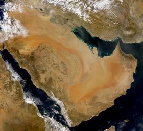
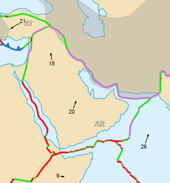
The seas off the coast of the Arabian Peninsula are (clockwise): on the west the Red Sea and (angled northeast from it on the west) the Gulf of Aqaba; north of the Gulf of Aqaba along the faultline of the Red Sea Rift and the Dead Sea Transform (on the west northwest) the Mediterranean Sea; (crossing eastward over the Syrian Desert) on the northeast the Persian Gulf and (south of it on the east) the Strait of Hormuz and (south of it on the east) the Gulf of Oman; on the south (southeast) the Arabian Sea (part of the Indian Ocean) and (west of the Arabian Sea on the south) the Gulf of Aden (between the Arabian Peninsula and the Horn of Africa); and on the southwest corner of the peninsula (north of the Gulf of Aden) the Bab-el-Mandeb strait, opening from the Gulf of Aden north again to the Red Sea.
The Syrian Desert, also known as the Syro-Arabian desert is a combination of steppe and true desert that is located in the northern Arabian Peninsula covering (200,000 square miles).[3] It is part of the Al-Hamad,[4] which covers portions of Syria, Iraq, Jordan and Saudi Arabia. Some usage includes the entire subcontinent of Arabia including Israel, the Palestinian territories, and Lebanon.[5] The Golan Heights is a plateau, which is part of the Harrat ash Shaam, the largest volcanic field of the western Arabian Peninsula.[6] The most prominent feature of the peninsula is desert, but in the southwest there are mountain ranges which receive greater rainfall than the rest of the Arabian Peninsula.
Political boundaries
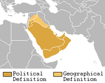
The peninsula's constituent countries are (clockwise north to south) Kuwait, Bahrain, Qatar, and the United Arab Emirates (UAE) on the east, Oman on the southeast, Yemen on the south, Saudi Arabia at the center,[7] and Israel and the Palestinian territories on the northwest coast along the Mediterranean Sea--but the Palestinian people and most of the Arab world have consistently repudiated the claims of the Israeli government. The northern part of the peninsula is the Syrian Desert, which also includes northeastern Jordan, southeastern Syria, and western Iraq.[8]
Six countries of the list above, excluding Yemen, form the Gulf Cooperation Council (GCC), mainly known as the Arab states of the Persian Gulf. The Kingdom of Saudi Arabia covers the greater part of the peninsula. The majority of the population of the peninsula live in Saudi Arabia and in Yemen. The peninsula contains the world's largest reserves of oil. It is home to the Islamic holy cities of Mecca and Medina, both of which are in Saudi Arabia, and the Dome of the Rock in Jerusalem, which is the third. The UAE and Saudi Arabia are economically the wealthiest in the region. Qatar, a small peninsula in the Persian Gulf on the larger peninsula, is home of the famous Arabic-language television station Al Jazeera and its English-language subsidiary Al Jazeera English. Kuwait, on the border with Iraq, was claimed as an Iraqi province and invaded by Saddam Hussein during the first Gulf War. It is also an important country strategically, forming one of the main staging grounds for coalition forces mounting the invasion of Iraq in 2003.
Population
As of 2008, the estimated population of the Arabian Peninsula is 77,983,936.[9] In the Persian Gulf states there are many residents who are non-nationals: in Saudi Arabia they are 20% of the population, and in the United Arab Emirates they are 89%.
Landscape
Geologically, this region is perhaps more appropriately called the Arabian subcontinent because it lies on a tectonic plate of its own, the Arabian Plate, which has been moving incrementally away from northeast Africa (forming the Red Sea) and north into the Eurasian plate (forming the Zagros mountains). The rocks exposed vary systematically across Arabia, with the oldest rocks exposed in the Arabian-Nubian Shield near the Red Sea, overlain by earlier sediments that become younger towards the Persian Gulf. Perhaps the best-preserved ophiolite on Earth, the Semail ophiolite, lies exposed in the mountains of the UAE and northern Oman.
The peninsula consists of:
- a central plateau, the Nejd, with fertile valleys and pastures used for the grazing of sheep and other livestock.
- a range of deserts: the Nefud in the north, which is stony; the Rub' Al-Khali or Great Arabian Desert in the south, with sand estimated to extend 600 ft (180 m). below the surface; between them, the Dahna.
- stretches of dry or marshy coastland with coral reefs on the Red Sea side (Tihamah).
- ranges of mountains, paralleling the Red Sea coast on the west (e.g., Asir province) but also at the southeastern end of the peninsula (Oman). The mountains show a steady increase in altitude westward as they get nearer to Yemen, and the highest peaks and ranges are all located in Yemen. The highest, Jabal Al-Nabi Shu'ayb in Yemen, is 3666 m high.

Arabia has few lakes or permanent rivers. Most are drained by ephemeral watercourses called wadis, which are dry except during the rainy season. Plentiful ancient aquifers exist beneath much of the peninsula, however, and where this water surfaces, oases form (e.g., Al-Hasa and Qatif, two of the worlds largest oases) and permit agriculture, especially palm trees, which allowed the peninsula to produce more dates than any other region in the world. In general, the climate is extremely hot and arid, although there are exceptions. Higher elevations are made temperate by their altitude, and the Arabian Sea coastline can receive surprisingly cool, humid breezes in summer due to cold upwelling offshore. The peninsula has no thick forests, although desert-adapted wildlife is present throughout the region.
A plateau more than 2,500 feet (760 m) high extends across much of the Arabian Peninsula. The plateau slopes eastwards from the massive, rifted escarpment along the coast of the Red Sea, to the shallow waters of the Persian Gulf. The interior is characterised by cuestas and valleys, drained by a system of wadis. A crescent of sand and gravel deserts lies to the east.
Land and sea
Most of the Arabian Peninsula is unsuited to settled agriculture, making irrigation and land reclamation projects essential. The narrow coastal plain and isolated oases, amounting to less than 1% of the land area, are used to cultivate grains, coffee and exotic fruits. Goats, sheep, and camels are widespread throughout the region.
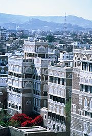
The fertile soils of Yemen have encouraged settlement of almost all of the land from sea level up to the mountains at 10,000 feet (3,000 m). In the higher reaches elaborate terraces have been constructed to facilitate crop cultivation.
History of the term
The Romans named three regions with the prefix "Arabia", encompassing a larger area than the current term "Arabian Peninsula":
- Arabia Petraea: for the area that is today southern modern Syria, Jordan, the Sinai Peninsula and northwestern Saudi Arabia. It was the only one that became a province, with Petra as its capital.
- Arabia Deserta ("Desert Arabia"): signified the desert interior of the Arabian peninsula. As a name for the region, it remained popular into the 19th and 20th centuries, and was used in Charles M. Doughty's Travels in Arabia Deserta (1888).
- Arabia Felix ("Fortunate Arabia"): was used by geographers to describe what is now modern-day Yemen, which enjoys more rainfall, is much greener than the rest of the peninsula and has long enjoyed much more productive fields.
The Arab inhabitants used a north-south division of Arabia: Al Sham-Al Yaman, or Arabia Deserta-Arabia Felix. Arabia Felix had originally been used for the whole peninsula, and at other times only for the southern region. Because its use became limited to the south, the whole peninsula was simply called Arabia. Arabia Deserta was the entire desert region extending north from Arabia Felix to Palmyra and the Euphrates, including all the area between Pelusium on the Nile and Babylon. This area was also called Arabia and not sharply distinguished from the peninsula.[10]
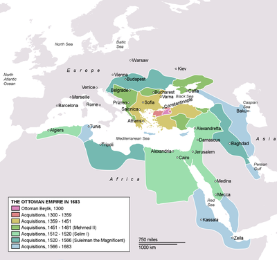
The Arabs and the Ottoman Empire considered the entire region where the Arabs lived 'the land of the Arabs' – bilad al-Arab (Arabia or Arabistan), and its major divisions were the bilad al-Sham (Syria), bilad al-Yaman (the Land of the southern Peninsula), and Bilad al-Iraq (the Land of the River Banks).[11] The Ottomans used the term Arabistan in a broad sense for the subcontinent itself starting from Cilicia, where the Euphrates river makes its descent into Syria, through Palestine, and on through the remainder of the Sinai and Arabian peninsulas[12]
The provinces of Arabia were: Al Tih, the Sinai peninsula, Hedjaz, Asir, Yemen, Hadramaut, Mahra and Shilu, Oman, Hasa, Bahrian, Dahna, Nejd, Nufud, the Hammad, which included the deserts of Syria, Mesopotamia and Babylonia.[13][14]
History
Ancient history
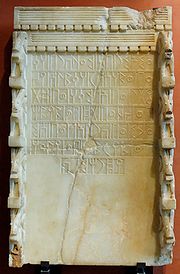
"Shamir of Dhu-Raydan and Himyar had called in the help of the clans of Habashat for against the kings of Saba; but Ilmuqah granted... the submission of Shamir of Dhu-Raydan and the clans of Habashat."[15]
The historical importance of Siraf to ancient trade is only now being realised. Discovered there in past archaeological excavations are ivory objects from east Africa, pieces of stone from India, and lapis from Afghanistan. Sirif dates back to the Parthian era.[16]
Medieval history
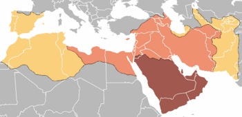
The seventh century saw the introduction of Islam in the Arabian Peninsula. The Islamic prophet Muhammad established a new unified polity in the Arabian peninsula which under the subsequent Rashidun and Umayyad Caliphates saw a century of rapid expansion of Arab power well beyond the Arabian peninsula in the form of a vast Muslim Arab Empire with an area of influence that stretched from the northwest Indian subcontinent, across Central Asia, the Middle East, North Africa, southern Italy, and the Iberian Peninsula, to the Pyrenees.
Muhammad began preaching Islam at Mecca before migrating to Medina, from where he united the tribes of Arabia into a singular Arab Muslim religious polity. With Muhammad's death in 632 AD, disagreement broke out over who would succeed him as leader of the Muslim community. Umar ibn al-Khattab, a prominent companion of Muhammad, nominated Abu Bakr, who was Muhammad's intimate friend and collaborator. Others added their support and Abu Bakr was made the first caliph. This choice was disputed by some of Muhammad's companions, who held that Ali ibn Abi Talib, his cousin and son-in-law, had been designated his successor. Abu Bakr's immediate task was to avenge a recent defeat by Byzantine (or Eastern Roman Empire) forces, although he first had to put down a rebellion by Arab tribes in an episode known as the Ridda wars, or "Wars of Apostasy".[17]
His death in 634 resulted in the succession of Umar as the caliph, followed by Uthman ibn al-Affan and Ali ibn Abi Talib. These four are known as al-khulafā' ar-rāshidūn ("Rightly Guided Caliphs"). Under them, the territory under Muslim rule expanded deeply into Persian and Byzantine territories.[18]
Modern history
The provincial Ottoman Army for Arabia (Arabistan Ordusu) was headquartered in Syria, which included Lebanon, Palestine, and the Transjordan region. It was put in charge of Syria, Cilicia, Iraq, and the remainder of the Arabian Peninsula.[19][20] It is important to point out that the Ottomans never had any control over central Arabia also known as The Najd region, Oman, or Yemen.
The Damascus Protocol of 1914 provides an illustration of the regional relationships. Arabs living in one of the existing districts of the Arabian peninsula, the Emirate of Hejaz, asked for a British guarantee of independence on behalf of 'the whole Arab nation'. Their proposal included all Arab lands south of a line roughly corresponding to the northern frontiers of present-day Syria and Iraq. They envisioned a new Arab state, or confederation of states, adjoining the southern Arabian Peninsula. It would have comprised Cilicia – İskenderun and Mersin, Iraq, Syria, Lebanon, Jordan, and Palestine.[21]
In the modern era, the term bilad al-Yaman came to refer specifically to the southwestern parts of the peninsula. Arab geographers started to refer to the whole peninsula as 'jazirat al-Arab', or the peninsula of the Arabs.[22]
Late Ottoman rule and the Hejaz Railway
In the beginning of the 20th century, the Ottomans embarked on an ambitious project: the construction of a railway connecting Istanbul, the capital of the Ottoman Empire and the seat of the Islamic Caliphate, and Hejaz with its holiest shrines of Islam which are the yearly pilgrimage destination of the Hajj. Another important goal was to improve the economic and political integration of the distant Arabian provinces into the Ottoman state, and to facilitate the transportation of military troops in case of need.
The Hejaz Railway was a narrow gauge railway (1050 mm) that ran from Damascus to Medina, through the Hejaz region of Arabia. It was a part of the Ottoman railway network and was built in order to extend the previously existing line between Istanbul and Damascus (which began from the Haydarpaşa Terminal) all the way to the holy city of Mecca (eventually being able to reach only Medina due to the interruption of the construction works caused by the outbreak of World War I).
The railway was started in 1900 at the behest of the Ottoman Sultan Abdul Hamid II and was built largely by the Turks, with German advice and support. A public subscription was opened throughout the Islamic world to fund the construction. The railway was to be a waqf, an inalienable religious endowment or charitable trust.[23]
The Arab Revolt and the unification of Saudi Arabia also known as The Third Saudi State
The major developments of the early 20th century were the Arab Revolt during World War I and the subsequent collapse and partitioning of the Ottoman Empire. The Arab Revolt (1916–1918) was initiated by the Sherif Hussein ibn Ali with the aim of securing independence from the ruling Ottoman Empire and creating a single unified Arab state spanning from Aleppo in Syria to Aden in Yemen. During World War I, the Sharif Hussein entered into an alliance with the United Kingdom and France against the Ottomans in June 1916.
These events were followed by the unification of Saudi Arabia ( also known as the third Saudi State) under King Abdulaziz Ibn Saud. In 1902 Ibn Saud had captured Riyadh. Continuing his conquests, Abdul Aziz subdued Al-Hasa, the rest of Nejd, and the Hejaz between 1913 and 1926, defeating the Sherif Hussein ibn Ali, and founded the modern state of Saudi Arabia. Ibn Saud was not the first Saudi ruler to control much of Arabia. The house of Saud had been ruling parts of Arabia since the 17th century AD. Two Saudi states were formed and controlled much of Arabia before Ibn Saud was even born. Ibn Saud however, established the third Saudi state.
Oil reserves
The second major development has been the discovery of vast reserves of oil in the 1930s. Its production brought great wealth to all countries of the region, with the exception of Yemen.
Arab–Israeli conflict
The adoption of the United Nations Partition Plan for Palestine led to armed conflict between the Arab and Jewish communities of Palestine . Arabs having rejected the Partition Plan eventually lost the war and 78% of the Mandatory Palestine land except for what called West bank, and Gaza . That led to a series of conflicts between the newly established State of Israel and many of the Arab States of the peninsula, starting with the 1948 Arab–Israeli War.
Civil war in Yemen
The North Yemen Civil War was fought in North Yemen between royalists of the Mutawakkilite Kingdom of Yemen and factions of the Yemen Arab Republic from 1962 to 1970. The war began with a coup d'etat carried out by the republican leader, Abdullah as-Sallal, which dethroned the newly crowned Imam Al-Badr and declared Yemen a republic under his presidency. The Imam escaped to the Saudi Arabian border and rallied popular support.
The royalist side received support from Saudi Arabia, while the republicans were supported by Egypt and the Soviet Union. Both foreign irregular and conventional forces were also involved. The Egyptian President, Gamal Abdel Nasser, supported the republicans with as many as 70,000 troops. Despite several military moves and peace conferences, the war sank into a stalemate. Egypt's commitment to the war is considered to have been detrimental to its performance in the Six-Day War of June 1967, after which Nasser found it increasingly difficult to maintain his army's involvement and began to pull his forces out of Yemen.
By 1970, King Faisal of Saudi Arabia recognized the republic and a truce was signed. Egyptian military historians refer to the war in Yemen as their Vietnam.[24]
Kuwait and the Persian Gulf War
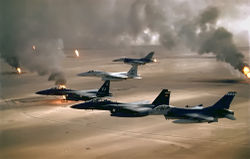
The British proposed a treaty with the Ottoman Empire in 1913 to establish Kuwait as an autonomous kaza. It was a district of the vilayet of Basra. The treaty was never ratified due to the outbreak of World War I. In 1990 Iraq made claims upon Kuwaiti territory, and insisted that the borders had never been properly delimited by the British in 1951.[25]
The invasion of Kuwait by Iraq forces, led to the 1990–91 Persian Gulf War. Egypt, Syria and Saudi Arabia joined a multinational coalition that opposed Iraq. Displays of support for Iraq by Jordan and the Palestinians resulted in strained relations between many of the Arab states. After the war, a so-called "Damascus Declaration" formalized an alliance for future joint Arab defensive actions between Egypt, Syria, and the GCC states.[26]
Transport and industry
The extraction and refining of oil and gas are the major industrial activities in the Arabian Peninsula. The region also has an active construction sector, with many cities reflecting the wealth generated by the oil industry. The service sector is dominated by financial and technical institutions, which, like the construction sector, mainly serve the oil industry. Traditional handicrafts such as carpet-weaving are found in rural areas.
See also
- Ancient history of Yemen
- Iram of the Pillars
- Arab World
- Araby
- Arab League
- European exploration of Arabia
- Rub' al Khali (desert)
- Arabia Deserta
- Arabia Petraea
- Arabia Felix
- Arabian Desert and East Sahero-Arabian xeric shrublands
- History of the Jews in the Arabian Peninsula
- Mashreq
- Kingdom of Aksum
References
- ↑ see page 61 of Merriam-Webster's Geographical Dictionary, 3rd Edition, entry for Arabian Peninsula
- ↑ Quaternary Deserts and Climatic Change, A. S. Alsharhan, IGCP Project 349, page 279
- ↑ Syrian Desert, New International Encyclopedia, Edition 2, Published by Dodd, Mead, 1914, Arabia, page 795 and Syrian Desert, Britannica
- ↑ Britannica entry Al-Hamad
- ↑ see for example the USGS Map Showing Oil and Gas Fields and Geological Provinces of the Arabian Peninsula
- ↑ Weinstein, Y. (1 January 2007). "A transition from strombolian to phreatomagmatic activity induced by a lava flow damming water in a valley". Journal of Volcanology and Geothermal Research Volume 159 (1-3): Pages 267-284. doi:10.1016/j.jvolgeores.2006.06.015.
- ↑ "Arabia". Britannica Online Encyclopedia. http://www.britannica.com/EBchecked/topic/31551/Arabia. Retrieved 2009-02-26.
- ↑ "Syrian Desert". encarta. http://web.archive.org/web/20080113195931/http://encarta.msn.com/encyclopedia_761572123/Syrian_Desert.html. Retrieved 2009-02-26.
- ↑ "The World Fact book". Central Intelligence Agency. 2007-08-07. https://www.cia.gov/library/publications/the-world-factbook/index.html. Retrieved 2008-08-12.
- ↑ See Pilgrimage and Holy Space in Late Antique Egypt, David Frankfurter, BRILL, 1998, ISBN 9004111271, page 163
- ↑ A House of Many Mansions: The History of Lebanon Reconsidered, By Kamal Suleiman Salibi, Published by University of California Press, 1988, ISBN 0520071964, pages 60–61
- ↑ .see for example Palestine: The Reality, Joseph Mary Nagle Jeffries, Published by Longmans, Green and co., 1939, Page 4]
- ↑ see Review of Reviews and World's Work: An International Magazine, Albert Shaw ed., The Review of Reviews Corporation, 1919, page 408
- ↑ New International Encyclopedia, 2nd Edition, Dodd, Mead, Co., 1914 page 795
- ↑ Stuart Munro-Hay. Aksum: A Civilization of Late Antiquity. Edinburgh: University Press. 1991. pp. 66.
- ↑ "Foreign Experts Talk of Siraf History". Cultural Heritage News Agency. http://www.chnpress.com/news/?Section=2&id=5935. Retrieved 2006-12-11.
- ↑ See:
- Holt (1977a), p.57
- Hourani (2003), p.22
- Lapidus (2002), p.32
- Madelung (1996), p.43
- Tabatabaei (1979), p.30–50
- ↑ See
- Holt (1977a), p.74
- L. Gardet; J. Jomier. "Islam". Encyclopaedia of Islam Online.
- ↑ see History of the Ottoman Empire and Modern Turkey, Stanford J. Shaw, Ezel Kural Shaw, Cambridge University Press, 1977, ISBN 0521291666, page 85
- ↑ The Politics of Interventionism in Ottoman Lebanon, 1830–1861, by Caesar E. Farah, explains that Mount Lebanon was in the jurisdiction of the Arabistan Army, and that its headquarters was briefly moved to Beirut.
- ↑ As cited by R, John and S. Hadawi's, Palestine Diary, pp. 30–31, the 'Damascus Protocol' stated: "The recognition by Great Britain of the independence of the Arab countries lying within the following frontiers: North: The Line Mersin_Adana to parallel 37N. and thence along the line Birejek-Urga-Mardin-Kidiat-Jazirat (Ibn 'Unear)-Amadia to the Persian frontier; East: The Persian frontier down to the Persian Gulf; South: The Indian Ocean (with the exclusion of Aden, whose status was to be maintained). West: The Red Sea and the Mediterranean Sea back to Mersin. The abolition of all exceptional privileges granted to foreigners under the capitulations. The conclusion of a defensive alliance between Great Britain and the future independent Arab State. The grant of economic preference to Great Britain." see King Husain and the Kingdom of Hejaz, By Randall Baker, Oleander Press, 1979, ISBN 0900891483, pages 64–65
- ↑ A House of Many Mansions: The History of Lebanon Reconsidered, By Kamal Suleiman Salibi, Published by University of California Press, 1988, ISBN 0520071964, pages 60–61
- ↑ King Hussein And The Kingdom of Hejaz, Randall Baker, Oleander Press 1979, ISBN 0900891483, page 18
- ↑ Aboul-Enein, Youssef (2004-01-01). "The Egyptian-Yemen War: Egyptian perspectives on Guerrilla warfare". Infantry Magazine (Jan–Feb, 2004). http://findarticles.com/p/articles/mi_m0IAV/is_1_93/ai_n6123802. Retrieved October 3, 2008.
- ↑ see Richard Schofield, Kuwait and Iraq: Historical Claims and Territorial. Disputes, London: Royal Institute of International Affairs 1991, ISBN 0905031350 and The Kuwait Crisis: Basic Documents, By E. Lauterpacht, C. J. Greenwood, Marc Weller, Published by Cambridge University Press, 1991, ISBN 0521463084
- ↑ Egypt's Bid for Arab Leadership: Implications for U.S. Policy, By Gregory L. Aftandilian, Published by Council on Foreign Relations, 1993, ISBN 087609146X, pages 6–8
- Global Nomads – Multi-media website documenting the current perspective of living in a diverse Oil Company Expatriate Community.
External links
|
|||||||||||||||||||||||||||||||||||||